[SURVEY OF THE MONTH] Virginia DOT Supports Unique ‘Rail to Trail’ Feasibility Study with MetroQuest Survey

Last month, we introduced the Survey of the Month blog: an exceptionally well-done example of a MetroQuest survey created by one of our users. We never cease to be amazed by the fantastic public engagement surveys that MetroQuest subscribers launch to gain valuable public input for their plans and we want to share their incredible work to congratulate them and to inspire you! Every month, we’ll show you how one agency or firm put together an outstanding survey and highlight a few take-aways to show you how to create engaging surveys of your own!
This month, we’re thrilled to present a unique feasibility study: turning a former railroad track into a shared use path along the eastern shore of Virginia, created by the Virginia Department of Transportation (VDOT). VDOT’s MetroQuest survey includes several great aspects that are applicable to a variety of other surveys, particularly those that ask for input on a map. Read on to learn more!
What’s the story? A Feasibility Study to Convert Rail Corridor into Shared Use Path Trails
VDOT initiated the Eastern Shore Rail to Trail Study to assess the feasibility of turning the former Bay Coast Railroad, an abandoned railroad corridor that spans about 50 miles along the eastern shore of Virginia, into a shared use path. The study evaluates existing conditions, identifies preferred alignments, and estimates cost associated with construction and maintenance. Potential connections into town and county destinations nearby are also considered.
As the former railroad runs mostly parallel to a major highway, converting it into a shared use path will create an active transportation corridor alongside the highway. This will increase mobility and accessibility, while also improving safety for pedestrians and bicyclists by reducing conflict points with vehicles. Collecting informed input from citizens allows VDOT to identify the level of interest and potential drawbacks to the conversion.
For more background information, please visit the study’s website at https://www.virginiadot.org/projects/hamptonroads/eastern_shore_rail_to_trail_study.asp
Anatomy of a Survey: How the Eastern Shore Rail to Trail Study Creatively Uses a MetroQuest Survey
The Eastern Shore Rail to Trail Study survey starts by presenting background information on the rail corridor and the project at hand before diving into the first activity: a survey that asks participants about their interest and potential uses for a future shared use path. This is intended to provide insight into places and activities of interest along the former railroad to help inform and support future plans for the corridor.
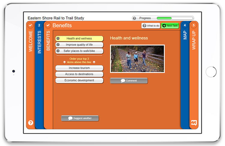
The survey then presents six possible benefits of the shared use trail, namely Health and wellness, Safer places to walk/bike, Improve quality of life, Access to destinations, Economic development, and Increase tourism, and asks participants to rank their top three.
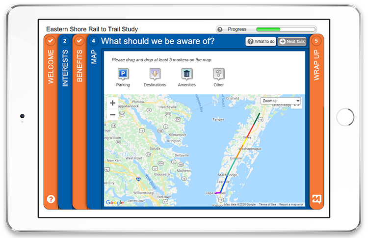
In a final activity, a map is presented for participants to provide feedback on where they want to see features such as trailheads with parking, destinations, or amenities. Asking for input on a map allows participants to provide spatial input, helping them to visualize the question and provide their answers in geographical context. It’s hugely valuable information for the agency as the map data can easily be uploaded into ArcGIS or a similar program for analysis.
If you’d like to try a demo of the survey, click here: https://esrailtrail-demo.metroquest.com/. This will not affect the survey results, so feel free to click around.
5 Tips from Eastern Shore Rail to Trail Study: How to Make an Effective Online Engagement Survey for Alternate Transportation Studies
The Eastern Shore Rail to Trail Study survey has many elements of a traditional survey, making it straightforward, but it also takes advantage of some great features of our online platform to make an overall experience that is very engaging and informative. Below are 5 aspects to keep in mind as you build your next MetroQuest survey to ensure that yours is just as successful:
- Generally, we suggest you keep your Welcome Screen, the landing page of the survey, simple and minimal. This makes the participant’s first experience inviting and unintimidating. VDOT’s survey does this well yet it also takes the added step of including the Study Area Map using the Welcome Screen pop up, a button at the bottom of the introduction that can be clicked to open a smaller screen. By adding a map of the Study Area here, VDOT shows participants the geographical area that the survey is focusing on right up front, helping them get oriented without cluttering the main screen.
- Another great feature that VDOT utilizes is the Zoom Options Dropdown on the map screen. It allows participants to zoom into specific areas or regions, pre-set by the survey creators, in order to give more precise input on the overall map. This can also help direct the participants’ attention to specific areas on the map that are most interesting or relevant to them.
- A great method for marking a map for survey participants is using a shape file, known as KML or KMZ, the way VDOT does. KML and KMZ stand for Keyhole Markup Language and Keyhole Markup Language Zipped respectively, the latter being a compressed version of the former. If all this is gibberish to you – it’s simply a way to display lines on the map, outlining or highlighting the study area. It allows participants to better understand the study area and hence, provide more precise and more informed input. Adding guidance through KMZ and Zoom Options help keep participants focused on the areas that are most relevant to them.
- On the Wrap Up Screen, you will see that VDOT includes a link to the project website for further information. While it’s likely that participants found the survey through the website, some may have been sent the link to the survey directly or arrived through other promotional sources such as Facebook or NextDoor, and will benefit from additional information. And even if the website is where they started, it’s a good idea to send them back at the end.
- A note on your demographic questions: keep them relevant to the project. VDOT did a fantastic job because in this case, knowing if participants live in or visit the area is important. Relevance is also understood by your participants, making it more likely for them to provide you with an answer. Demographic information can also help your team reach a diverse range of participants, as MetroQuest’s data center will show aggregated data of whatever demographic questions are included in the survey. This will allow you to re-target the groups that are underrepresented in the results.
While this survey only recently closed, we were given permission to share their incredible numbers: 3,400 participants took the survey in just a few weeks, with both visitors and local residents generating over 50,000 datapoints!
Congratulations to the Virginia DOT team for the engaging survey and amazing numbers!
For more great tips on how to make the most out of MetroQuest, contact your Customer Experience manager or reach out for more information!
Want to learn more about MetroQuest? Check out our recent webinar:
Indianapolis MPO’s Formula for Actionable Public Input on Bike, Ped & Transit
Meaningful public input is critical to creating bike, pedestrian and transit plans that truly meet the needs of the communities they serve. Join Indianapolis MPO for a fast-paced tour through its ground-breaking formula for engaging the public in alternative transportation planning.


![[Bike & Ped - man with tablet on bench]](https://metroquest.com/wp-content/uploads/Bike-Ped-man-with-tablet-on-bench-portfolio-image.png)