[SURVEY OF THE MONTH] Shaping the Future of Transportation in Baton Rouge, LA
![[SURVEY OF THE MONTH] Shaping the Future of Transportation in Baton Rouge, LA [SURVEY OF THE MONTH] Shaping the Future of Transportation in Baton Rouge, LA](https://metroquest.com/wp-content/uploads/SURVEY-OF-THE-MONTH-Shaping-the-Future-of-Transportation-in-Baton-Rouge-LA.png)
The Survey of the Month series is a monthly blog where we highlight the extraordinary work our customers are doing, along with some takeaways that are relevant for anyone interested in making the most out of online engagement using MetroQuest’s survey platform! To see more in the series, visit the blogs here.
The Capital Region Planning Commission (CRPC) in Louisiana is a Council of Governments serving eleven parishes around Baton Rouge. The agency coordinates and addresses regional issues related to transportation, land use, economic development and the environment. It is the Baton Rouge area’s designated Metropolitan Planning Organization (MPO).
As such, CRPC focuses a large part of its resources on transportation planning, including the federally mandated update to its Metropolitan Transportation Plan (MTP) every four years. MOVE2046 is the Capital Region’s MTP, and the team utilized a MetroQuest survey to great effect!
Let’s take a look at what they did…
What’s the story? Developing the future of transportation in LA with MOVE2046
MOVE2046 creates the future of transportation in the region by developing goals, strategies, and projects that will help achieve a vision over the next 25 years. The plan encompasses half of the parishes that the MPO serves, and is developed in coordination with local governments as well as key stakeholders to make certain that it supplements, rather than hinders, existing plans in the region.
Broad community engagement around the plan ensures the public has ample opportunity to get involved and help shape the plan’s vision, goal, and recommendations with their input. Currently, the project is in its second stage where options are being evaluated. For more information, please visit https://crpcla.org/move2046.
Anatomy of a Survey: A Classic LRTP Survey for Engagement
Long-range transportation plans (LRTPs) have traditionally been the single most common use of MetroQuest, from back in the early days of our software to now! MetroQuest can be (and is) applied to any planning context, and the MOVE2046 plan demonstrates just how exceptional an online survey can be for transportation plans.
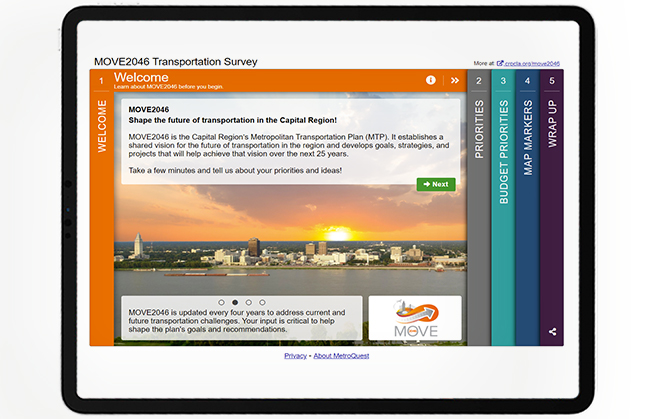
After the Welcome Screen, which informs visitors of the plan and of the survey’s purpose, participants are asked to rank their priority items out of a list of 7, namely (in random order) Improve Connectivity, Improve Walking and Biking, Support the Movement of Freight, Improve Public Transit, Improve Safety, Maintain What We Have, and Reduce Traffic Congestion. This Priority Ranking Screen allows participants to tell the survey team what is most important to them.

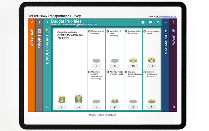
On the next Screen, participants are asked to distribute a fictitious but representative budget of $100 into eight possible categories, namely Maintain What We Have, Move Freight More Efficiently, Improve Safety for All Users, Improve Public Transit, Maximize Existing Network with Technology, Add New Roads or Widen Roads, Improve Bike/Pedestrian Facilities, and Improve Streetscape Appearance. It is a gamified experience asking for priorities while also highlighting the fact that funds are finite!
The last interactive Screen, before wrapping up the survey with demographic questions and ways to stay involved, is a Map Marker Screen which asks participants to show the region’s biggest needs by dropping markers onto a map of the area in question. The marker options are Congestion, Bicycle and Pedestrian, Public Transit, Safety, Maintenance, and Other. This type of Screen allows participants to tell the survey team exactly where they see issues and opportunities!
You can try the MOVE 2046 survey here. This is a demo version that will not affect the survey results.
5 Tips from MOVE2046: Good survey design is all in the details!
The MOVE2046 Survey made the most of MetroQuest’s capabilities to serve their LRTP purpose! Below are 5 takeaways from their survey that can help you when designing your next public engagement survey:
- Visitors landing on the MOVE2046 Welcome Screen are greeted by a beautiful background image along with rotating factoids. It is a simple yet very effective way to make the landing page eye-catching!
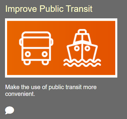
- Each priority has a short description and uses an icon image to convey the meaning. Icons are a great way to supplement description of items as it keeps the Screen simple. Images are also popular! We know it can be a challenge to find what you are looking for, so we’ve created the updated image library for some inspiration and images to use; there are over 400 stock image that can be searched by keyword! You can access the Image Library from your MetroQuest Studio.
- On the Budget Allocation screen, the survey team kept each of the categories short and to the point for maximum appeal and ease of use. However, they also made use of the “additional information” bubble for anyone who might want a bit more context on any of the categories. This is a great way to serve those who wish to know more without overwhelming the main area with too much text.
- On the Map Marker Screen, each marker has a sub question with a drop down and a textbox, giving participants a space to elaborate on their choice. This enables the survey team to capture qualitative data that will help inform the plan, in addition to the quantitative spatial input!
- Also on the Map Marker Screen, the survey team made use of the location drop down at the bottom right which allows participants to zoom into the area that is most interesting or concerning to them. This gives more precise and nuanced input by helping participants get to where they need on the map.
Congratulations to the team at CRPC for a well-executed project and a fantastic LRTP survey experience!
For more great tips on how to make the most out of MetroQuest, contact your Customer Experience manager or reach out for more information!
Want to learn more about how MetroQuest supports teams in achieving successful community outreach? Read about COMPASS’s success!
COMPASS Gathers Input from 18,500+ Participants to Plan Future Transportation
To help shape the future of the region into the year 2050, local planning officials at COMPASS in Southwest Idaho turned to the public for input and achieved record-breaking results!


